Geography of South Africa
| Geography of South Africa | |
|---|---|
 |
|
| Continent | Africa |
| Region | Southern Africa |
| Area | Ranked 25th 1,221,037 km2 (471,445.0 sq mi) |
| Borders | Total land borders: 4,862 km Botswana 1,840 km, Lesotho 909 km, Mozambique 491 km, Namibia 967 km, Swaziland 430 km, Zimbabwe 225 km |
| Highest point | Mafadi 3,450 m |
| Lowest point | Sea level 0 m |
| Longest river | Orange River 2,200 km |
| Largest lake | Lake Chrissie |
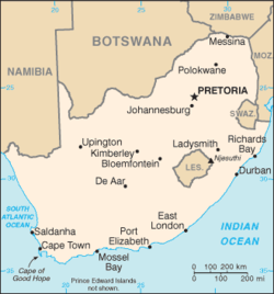
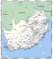
South Africa occupies the southern tip of Africa, its coastline stretching more than 2,500 km (1,553 mi) from the desert border with Namibia on the Atlantic (western) coast southwards around the tip of Africa and then north to the border with Mozambique on the Indian Ocean. The low-lying coastal zone is narrow for much of that distance, soon giving way to a mountainous escarpment (Great Escarpment) that separates the coast from the high inland plateau. In some places, notably the province of KwaZulu-Natal in the east, a greater distance separates the coast from the escarpment. Although most of the country is classified as semi-arid, it has considerable variation in climate as well as topography.
Contents |
General information
- Area
- total: 1,219,912 square kilometres (471,011 sq mi)
- land: 1,219,912 square kilometres (471,011 sq mi)
- water: 0 square kilometres (0 sq mi)
- note: includes Prince Edward Islands (Marion Island and Prince Edward Island)
- Maritime claims
- territorial sea: 12 nmi (22 km; 14 mi)
- contiguous zone: 24 nmi (44 km; 28 mi)
- exclusive economic zone: 200 nmi (370 km; 230 mi)
- continental shelf: 200 nmi (370 km; 230 mi) or to edge of the continental margin
- Natural resources
gold, chromium, antimony, coal, iron ore, manganese, nickel, phosphates, tin, uranium, gem diamonds, platinum, copper, vanadium, salt, natural gas
- Land use
- arable land: 12.1%
- permanent crops: 0.79%
- other: 87.11% (2005)
- Irrigated land
- 14,980 square kilometres (5,784 sq mi) (2003)
- Natural hazards
- prolonged droughts
- Environment - issues as of 2010[update]
- lack of important arterial rivers or lakes requires extensive water conservation and control measures; growth in water usage outpacing supply; pollution of rivers from agricultural runoff and urban discharge; air pollution resulting in acid rain; soil erosion; desertification
- Environment - international agreements
- party to: Antarctic-Environmental Protocol, Antarctic-Marine Living Resources, Antarctic Seals, Antarctic Treaty, Biodiversity, Climate Change, Climate Change-Kyoto Protocol, Desertification, Endangered Species, Hazardous Wastes, Law of the Sea, Marine Dumping, Marine Life Conservation, Ozone Layer Protection, ship pollution, Wetlands, Whaling
General geography
By far South Africa's biggest neighbour is the ocean—or two oceans, which meet at the southwestern corner. Its territory includes Marion and Prince Edward Islands, nearly 2,000 km (1,243 mi) from Cape Town in the Atlantic Ocean.
The cold Benguela current sweeps up from the Antarctic along the Atlantic coast, laden with plankton and providing rich fishing-grounds. The east coast has the north-to-south Mozambique/Agulhas Current, which provide its warm waters. These two currents have a major effect on the country's climate, the ready evaporation of the eastern seas providing generous rainfall while the Benguela current retains its moisture to cause desert conditions in the west.
Several small rivers run into the sea along the coastline, but none are navigable and none provide useful natural harbours. The coastline itself, being fairly smooth, provides only one good natural harbour, at Saldanha Bay north of Cape Town. A lack of fresh water prevented major development here. Nevertheless, busy harbours now exist at Cape Town, Port Elizabeth, East London, Durban, and Richards Bay.
On dry land, going from west to east, the country shares long borders with Namibia and Botswana, touches Zimbabwe, has a longitudinal strip of border with Mozambique to the east, and lastly curves in around Swaziland before rejoining Mozambique's southern border. In the interior, nestled in the curve of the bean-shaped Free State, lies the small mountainous country of Lesotho, completely surrounded by South African territory.
There are only two major rivers: the Limpopo, a stretch of which is shared with Zimbabwe, and the Orange (with its tributary, the Vaal) which runs with a variable flow across the central landscape from east to west, emptying into the Atlantic Ocean at the Namibian border. In so dry a country, dams and irrigation are extremely important: the largest dam is the Gariep on the Orange River.
The total land area of South Africa is slightly more than 1,200,000 km2 (463,000 sq mi), and it measures some 1,600 km (994 mi) from north to south and approximately the same from east to west.
Climate
See also: Climate
|
|||||||||||||||||||||
The Karoo, which occupies a large part of the western Central Plateau, has a climate extremely hot in summer and bitterly cold in winter. In contrast, the eastern coastline on the Indian Ocean is lush, well watered and warmed by the Mozambique Current; patches of Southern Africa mangroves grow along this coast.
The southern coast, part of which is known as the Garden Route, is temperate and green. The Cape of Good Hope has a Mediterranean climate, with cool, wet winters and warm, dry summers (becoming hotter in interior valleys). Snow commonly falls in winter on the higher ground of the Cape Fold Mountains. The Cape has a reputation for its wind - which blows intermittently virtually all year round, either from the south-east or the north-west - and for its sunny summer, when almost no rain falls. The vegetation of the Cape area consists of fynbos grassland and Albany thickets.
The eastern section of the Karoo does not extend as far north as the western part, giving way to the flat landscape of the Free State, which though still semi-arid receives somewhat more rain. North of the Vaal River the Highveld is better watered, its annual rainfall is 760 mm (29.9 in) and due to its high altitude (around 1,750 m/5,741 ft) is saved from extremes of heat. Winters are cold, though snow is rare.
Further north and to the east, especially where a drop in altitude beyond the escarpment gives the Lowveld its name, temperatures rise: the Tropic of Capricorn slices through the extreme north. Here one finds the typical South African Bushveld. There is skiing in winter in the high Drakensberg mountains that form the eastern escarpment, but the coldest place in the country is Sutherland in the western Roggeveld Mountains, with midwinter temperatures as low as −15 degrees Celsius. The deep interior provides the hottest temperatures: in 1948 the mercury hit 51.7 °C (125.06 °F) in the Northern Cape Kalahari near Upington.
The Central Plateau
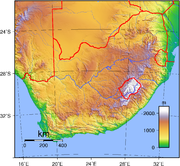
The Central Plateau has a large range of landscape. It is drained by two major rivers, the Orange and the Limpopo, and is made up of 10 smaller geographic regions. The altitude varies from 600 to 2,500 m and the rainfall varies from 200 to 1200 mm annually. It is ringed in the east, south and west by the Great Escarpment. In general the Great Escarpment slowly loses altitude into the northwestern areas of the Central Plateau. In the west it is very dry, merging with the Kalahari in the northwest. In the central areas the arid scrubland gives way to dry grasslands which become better watered further to the east. These grasslands extend northeastward until they reach the Witwatersrand and Magaliesberg, which are the main watershed between the Orange and Limpopo Rivers. The Witwatersrand and Magaliesberg also form part of an area of low mountain ranges surrounding a basin called the Bushveld. To the north of that the semi-arid savanna loses altitude towards the Limpopo River valley. The regions are outlined in more detail below.
Regions of higher elevation
- Cape or Ghaap Plateau
- This region lies between Kimberley and Upington, north of the Orange River to the Kuruman Hills.
- Summer days are very hot. In winter, the nights are very cold with frost but the days are warm and sunny.
- It has Kalahari Thornveld and Kalahari Shrub Bushveld Vegetation
- The altitude varies between 900 and 1 600 m.
- The mean annual precipitation varies from 200 to 600 mm.
- The minimum and maximum mean daily temperature varies from 14 to 32 °C in summer and between 0 and 20 °C in winter.
- Free State Plateau
- This region occupies the entire Free State Province apart from the highlands east of Bethlehem north to the Vaal Dam. Its northern border is the Vaal River. In the north and east it merges with the Highveld. Some sources regard the Free State Plateau and the Highveld as one area with the name The Highveld.
- Mostly grassland plains with low hills. These hills increase to the south and south-east where they transform into the Northern Karoo Plateau and The Lesotho Highlands respectively. The altitude varies between 1 250 and 1 700 m.
- temp + weather
- Highveld
- The Highveld is made up of open rolling grasslands/grassveld with open hills. It has higher elevations in the north and east, where it has a mountainous/hilly border, the Magaliesberg and Witwatersrand in the north and the Mpumalanga escarpment five in the east. It generally loses altitude to the west where the grassveld merges with the Kalahari shrub bushveld.
- It occupies the eastern region of the Free State Province, southern Mpumalanga, central and southern Gauteng and the eastern parts of the North West Province south of the Magaliesberg.
- The altitude varies between 1 250 and 1 750 m, with a mean annual temperature of between 14 and 18 °C. Winters are cold, though snow is rare and due to its high altitude it is saved from extreme summer temperatures.
- It receives between 400 and 1200 mm of rain annually. This is due to the east/west distribution of rainfall in South Africa, variations in relief, and annual variation in rainfall.
- Lesotho Highlands
- This area lies within the borders of The Kingdom of Lesotho. Its eastern and southern borders are the Drakensberg or uKhahlamba Mountains, the highest part of the Great Escarpment.
- This region is the highest in the central plateau and is dominated by high mountains with deeply incised valleys and open highlands, deeply incised, in the east.
- The altitude varies from 1 280 to 2 818 m
- The vegetation is a mix of alpine veld, mountain grassveld and isolated patches of afromontane forest in some valleys.
- This region experiences severe frost in winter. Snow is common.
- Limpopo Highlands
- This region lies in the Northern Province and runs east-west following the general curve of the Limpopo River for about 350 km. It is made up of, in the majority, the Waterberg in the west and central areas, then the Blouberg and lastly the Soutpansberg in the east. The Soutpansberg is also part of the most north eastern part of the great Escarpment.
- The region is made up of low mountains, table lands and some high mountains. The altitude varies between 800 to 1 750 m. The Blouberg has a 300 m north wall famous among rock climbers.
- The vegetation is made up of arid mountain bushveld, Semi-deciduous Scrub Forests, Afromontane Grassland and isolated patches of Afrotemperate Mist-belt Forests.
- It receives between 400 and 800 mm of precipitation annually. The temperature varies from 14 - 20 °C annually.
- Northern Karoo Plateau / Upper Karoo
- This region lies across the Southern parts of the Northern Cape Province and the northern parts of The Eastern Cape Province. Its southern border is The Great Escarpment. It runs from Calvinia in the west to the Lesotho border in the east which is about 700 km.
- The town Sutherland is located in the west of the Northern Karoo Plateau in the Roggeveld Mountains, with midwinter temperatures as low as −15 degrees and is thought to be the coldest inhabited place in South Africa.
- This area is part of a much larger region called the Karoo which covers approximately 35% of South Africa.
- The average annual rainfall is between 300 and 500 mm. The altitude varies from 1 200 to 1 750 m
Low-lying regions
- Bushveld Basin
- This Region lies in an east-west orientation, on an area approximately 350 kilometres by 150 kilometres. It is surrounded by hills, some of which are, the Magaliesberg and Witwatersrand in the south, the Waterberg in the north and the Mpumalanga escarpment in the east.
- It is famous for its open, tree covered grasslands and below ground the Bushveld igneous complex, which has some of the world’s major chromium, vanadium and platinum deposits.
- The altitude varies from 600 to 1 500 m with average precipitation varying between 400 to 800 mm annually.
- The word Bushveld can be used in terms of Geography and Vegetation. Bushveld used in reference to vegetation occurs in a much larger area within Southern Africa.
- Cape Middleveld
- The Cape Middleveld is the most westerly region in the interior plateau. Its northern and eastern border is the Orange River, to the west the Great Escarpment and to the south the Northern Karoo Plateau.
- It comprises an open plain with low relief. Very little rain falls, and the summers are very hot.
- The altitude varies between 300 and 900 m.
- The mean annual precipitation varies from 100 to 400 mm.
- The minimum and maximum mean daily temperature varies from 12 to 32 °C in summer and between 0 and 22 °C in winter.
- Kalahari Basin
- The Middle Limpopo Valley or Limpopo Plain
- Bordered in the north by the Limpopo River and in the south by the Waterberg and Soutpansberg ranges.
- Vegetation dominantly Bushveld in the west and Mopane veld in the east.
- Mean annual rainfall 200-600 mm.
- Temperatures range from 2 °C - 32 °C with mean annual temp between 18 °C - 22 °C.
Extreme points
This is a list of the extreme points of South Africa, the points that are farther north, south, east or west than any other location in the country.
South Africa
- Northernmost Point — Beit Bridge, Limpopo Province (22°20'S)
- Southernmost Point — Marion Island, Prince Edward Islands (46°54'S)
- Westernmost Point — Alexander Bay, Northern Cape (16°31'E)
- Easternmost Point — Prince Edward Island, Prince Edward Islands (38°02'E)
South Africa (mainland)
- Northernmost Point — Beit Bridge, Limpopo Province (22°20'S)
- Southernmost Point — Cape Agulhas, Western Cape (34°51'S)
- Westernmost Point — Alexander Bay, Northern Cape (16°31'E)
- Easternmost Point — Kosi Bay, KwaZulu-Natal
See also
- Provinces of South Africa
- Districts of South Africa
- Municipalities of South Africa
- List of rivers of South Africa
References
- Some material in this article is adapted from the World Factbook 2006.
- http://www.dwaf.gov.za/iwqs/gis_data/ecoregions/get-ecoregions.htm
- http://www.dwaf.gov.za/IWQS/gis_data/ecoregions/LEVEL_I_ECOREGIONSsigned_small2.pdf Kleynhans, CJ, Thirion, C and Moolman, J (2005). A Level I River Ecoregion classification System for South Africa, Lesotho and Swaziland. Report No. N/0000/00/REQ0104. Resource Quality Services, Department of Water Affairs and Forestry, Pretoria, South Africa.
- http://academic.sun.ac.za/botzoo/mucina/ProcIAVS_Bushveld.pdf
- http://www.mantleplumes.org/Penrose/PenPDFAbstracts/Elston_Wolf_abs.pdf
- http://www.unhcr.org/home/RSDCOI/447aae394.pdf
- http://www.plantzafrica.com/frames/vegfram.htm
- http://whc.unesco.org/en/statesparties/za
|
||||||||||||||||||||||||||||||||||||||
|
|||||||||||